Lombok
From Wikipedia, the free encyclopedia

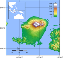
Topography of the island
|
|
| Geography | |
|---|---|
| Location | South East Asia |
| Coordinates | 8.565°S 116.351°ECoordinates: 8.565°S 116.351°E |
| Archipelago | Lesser Sunda Islands |
| Area | 4,725 km2 (1,824 sq mi) |
| Highest elevation | 3,726 m (12,224 ft) |
| Highest point | Rinjani |
| Country | |
|
Indonesia
|
|
| Province | West Nusa Tenggara |
| Largest city | Mataram |
| Demographics | |
| Population | 3,166,685 (as of 2010 Census) |
| Density | 670 /km2 (1,740 /sq mi) |
| Ethnic groups | Sasak, Balinese, Tionghoa-peranakan, Sumbawa people, Flores people, Arab Indonesian |
Lombok is an island in West Nusa Tenggara (Nusa Tenggara Barat or NTB) province, Indonesia. It forms part of the chain of the Lesser Sunda Islands, with the Lombok Strait separating it from Bali to the west and the Alas Strait between it and Sumbawa to the east. It is roughly circular, with a "tail" (Sekotong Peninsula)
to the southwest, about 70 km across and a total area of about
4,725 km² (1,825 sq mi). The provincial capital and largest city on the
island is Mataram. It is somewhat similar in size and density with neighboring Bali and shares some cultural heritage, but is administratively part of NTB along with sparsely populated Sumbawa. It is surrounded by a number of smaller islands locally called Gili.
The island is home to some 3.16 million Indonesians [1][2][3] as recorded in the decennial 2010 census, and in 4 regencies along with the provincial capital Mataram.


0 komentar:
Posting Komentar